

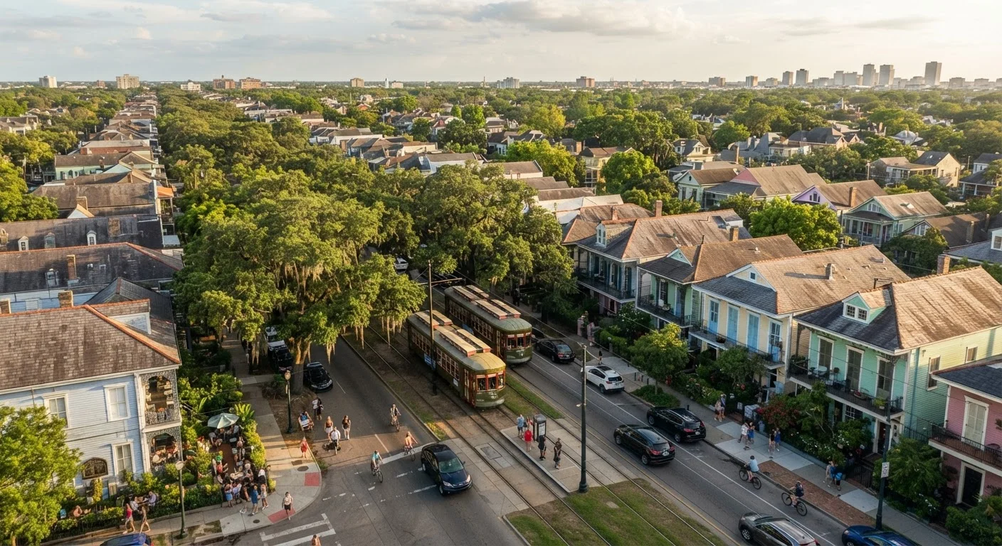
How New Orleans Is Actually Laid Out
New Orleans doesn't follow a standard grid. Its streets curve along the Mississippi River, which is why locals use directions like "toward the river" or "toward the lake" rather than cardinal compass points. Understanding this basic layout prevents a lot of confusion when navigating between neighborhoods.
The city is broadly divided into two halves: the historic Upriver side (think the French Quarter and neighborhoods extending upriver toward Audubon Park) and the sprawling Downriver side. Most visitors concentrate in a relatively small area, but the city rewards those willing to venture further. If you're arriving in an unfamiliar city for the first time, practical orientation strategies can make navigating New Orleans significantly less overwhelming.
Neighborhood by Neighborhood: What to Realistically Expect
French Quarter
The French Quarter is New Orleans' most visited neighborhood and its most misunderstood. Bourbon Street delivers exactly what its reputation promises - loud, crowded, and open around the clock. But just a few blocks away, quieter streets like Frenchmen-adjacent Royal Street and Chartres Street offer galleries, historic architecture, and local restaurants. Expect heavy foot traffic on most days, especially weekends. The Quarter is compact and walkable, but it can feel overwhelming without a plan.
Tremé
Immediately adjacent to the French Quarter, Tremé is widely recognized as one of the oldest African American neighborhoods in the country and a cradle of jazz culture. It's more residential and far less tourist-saturated. Visitors who walk into Tremé find community life, brass band culture, and historic churches. Exercise the same street awareness you would in any urban neighborhood - stay oriented and aware, particularly after dark.
Marigny and Bywater
The Marigny sits just downriver from the Quarter and has a bohemian, walkable character. Frenchmen Street here is where many locals - not tourists - go for live music. Bywater, continuing downriver, is more residential and increasingly popular with younger residents. Both neighborhoods are flat and bikeable. Crime statistics vary by block, so consult current local resources before exploring at night.
Garden District and Uptown
The Garden District is notable for its antebellum mansions and oak-canopied streets. It's quieter than the Quarter and generally considered comfortable for walking during daylight hours. The St. Charles Avenue streetcar connects this area to downtown and is one of the most practical - and scenic - ways to move between neighborhoods. Uptown extends further along the river and includes Tulane and Loyola universities, giving it a more neighborhood-driven feel.
Mid-City and Bayou St. John
Mid-City is largely residential but anchored by City Park, one of the largest urban parks in the country. Bayou St. John, running through the area, is a pleasant place to walk and picnic. This is where you get a clearer sense of everyday New Orleans life - fewer tourist venues, more local coffee shops and neighborhood restaurants.
A Note on Safety and Street Awareness
New Orleans, like any major city, has neighborhoods with higher crime rates than others. Conditions vary significantly by block, time of day, and season. Consulting current local resources - such as the city's crime mapping tools or travel advisories - is more reliable than generalized reputation. Basic urban awareness: stay in well-lit, populated areas at night, secure your belongings, and let someone know your plans.
Algiers Point
Located directly across the Mississippi from the French Quarter, Algiers Point is accessible via a free ferry. It's a small, historic neighborhood with a quiet main street and river views. Most visitors overlook it entirely, which is exactly why it's worth a short excursion.
Practical Considerations Before You Go
New Orleans has a subtropical climate - summers are genuinely hot and humid, with frequent afternoon thunderstorms. Spring and fall offer more moderate temperatures. Hurricane season runs June through November, which is worth factoring into planning. Flooding can affect some lower-lying neighborhoods after heavy rain.
Transportation options include the streetcar lines, rideshare, and bikes. Parking is limited and can be expensive near the Quarter. Always verify current conditions, entry requirements, and any travel advisories with official sources before your trip - neighborhood conditions and city services can shift, and no guide substitutes for current, authoritative information.
Creole Cottage
A style of vernacular architecture common in New Orleans, typically a small, single-story structure built close to the street, often with a front gable and side-hall layout. They're especially common in Tremé and the Marigny.
Neutral Ground
The local New Orleans term for a median strip running down the center of a boulevard. St. Charles Avenue's neutral ground is where the historic streetcar tracks run.
Lakeward / Riverside
Directional terms used in New Orleans to orient navigation. 'Riverside' means toward the Mississippi River; 'lakeward' means toward Lake Pontchartrain. Used because the city's curved layout makes standard compass directions confusing.
Second Line
A New Orleans tradition in which a brass band parade moves through the streets, with a 'second line' of community members and spectators following behind. These are genuine community events, not staged performances, and occur regularly in neighborhoods like Tremé.
The content on this site is for informational purposes only and is not a substitute for professional advice. Always consult a qualified professional for guidance specific to your situation.