

Understanding the Overseas Highway
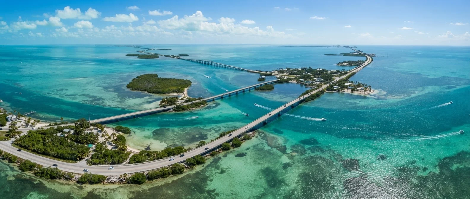
US-1 through the Florida Keys - commonly called the Overseas Highway - runs about 113 miles from Florida City on the mainland to Key West. It crosses 42 bridges, including the iconic Seven Mile Bridge, and passes through or near more than 40 inhabited islands. The road is almost entirely two lanes, which means a single accident or drawbridge opening can add an hour to your drive with no way around it.
Mileposts (MM) are the practical navigation system locals use. MM 126 is near the mainland end; MM 0 is in Key West. Every business, campground, and boat ramp is referenced this way. Download an offline map and note mileposts for your stops before you leave cell range - service can be inconsistent over open water stretches.
No Alternate Routes Exist
US-1 is the only road in and out of the Keys. In the event of a hurricane evacuation order, contraflow procedures convert both lanes to outbound traffic - but delays can still be significant. Travelers should monitor the Monroe County Emergency Management website and local advisories during any active tropical weather system.
The drive end to end, without stops, takes roughly two and a half to three hours under normal conditions. With sightseeing, meals, and typical traffic near Key West, a first-time traveler should budget a full day minimum. Most visitors spread the trip across two or more days.
Key Largo: The Dive Capital Entry Point
Key Largo (MM 106 to MM 90) is the longest and northernmost key. It markets itself as the dive capital of the world, a claim grounded in genuine reef access. John Pennekamp Coral Reef State Park - the first underwater state park in the United States - sits just offshore and offers snorkel tours, glass-bottom boat trips, and scuba diving into living coral ecosystems. Reservations for tours fill quickly in season; book in advance through the park's official channels.
Beyond the water, Key Largo has a working-town character that surprises visitors expecting a resort strip. Chain restaurants and strip malls sit alongside bait shops and fish houses. That authenticity is part of its appeal for travelers who want access to reefs without Key West's noise, but it means the island won't satisfy those seeking polished amenities.
If reef diving or snorkeling is your main goal, base yourself in Key Largo for at least one night rather than trying to day-trip from Miami - morning water conditions are calmer and boats depart early.
Afternoon wind typically picks up in the Keys, reducing visibility and increasing chop. Morning departures consistently offer better conditions for underwater activities.
Use the mile marker system to plan your stops in advance on paper or offline - don't rely solely on cell navigation when driving over open-water bridge sections.
Cell service can drop on longer bridge spans, and pulling over safely on a two-lane causeway is difficult. Pre-planning prevents missed turns and unnecessary U-turns on a road with few of them.
Islamorada to Marathon: The Middle Keys
Islamorada (roughly MM 90 to MM 73) calls itself the sport fishing capital of the world, and the concentration of charter boats and fishing lodges makes that credible. The village - actually a collection of several islands - also has a more developed restaurant and lodging scene than Key Largo. Robbie's Marina at MM 77.5 is a reliable stop: it offers inexpensive tarpon feeding from the dock, kayak rentals, and boat charters in one place.
Marathon (MM 63 to MM 47) sits at the geographic midpoint and functions as a supply hub. The Turtle Hospital here accepts injured sea turtles for rehabilitation and offers educational tours - reservations are required. The Pigeon Key Historic District, accessible by ferry from the Seven Mile Bridge, preserves the original workers' camp built during Henry Flagler's railroad era. Marathon is a practical overnight base if you're splitting the drive over two days.
113 miles
Length of the Overseas Highway, MM 126 to MM 0
The route crosses 42 bridges and connects more than 40 inhabited islands between Florida City and Key West.
~800
Estimated Key deer population in the wild
The U.S. Fish and Wildlife Service manages the National Key Deer Refuge on Big Pine Key to protect this endangered subspecies.
7 miles
Length of the Seven Mile Bridge
Completed in 1982, the current bridge replaced Flagler's original railroad bridge and remains one of the longest segmental bridges in the world.
Big Pine Key and the Lower Keys
South of Marathon, the landscape quiets noticeably. Big Pine Key (MM 33 to MM 30) is home to the National Key Deer Refuge, which protects the endangered Key deer - a miniature subspecies of the white-tailed deer standing roughly 24 to 28 inches tall at the shoulder. Driving through the refuge requires strictly obeying posted speed limits (some sections drop to 15 mph at night). Feeding or approaching the deer is illegal and genuinely harmful to the population.
Bahia Honda State Park (MM 37) is widely considered one of the finest beaches in the Florida Keys - an honest assessment for a region where true sandy beaches are relatively rare. Camping here is popular and books months ahead during peak season. The nearby Looe Key National Marine Sanctuary offers reef diving that rivals Pennekamp with thinner crowds.
Key West: What the Hype Gets Right and Wrong
Key West (MM 0 to MM 4) delivers genuine history, architecture, and culture - and genuine crowds. Duval Street, the main nightlife corridor, can feel overwhelming, especially during Fantasy Fest, spring break, or holiday weekends. The historic district away from Duval - Bahama Village, the seaport, and residential streets lined with conch-style houses - offers a quieter and more representative picture of the island.
Fort Zachary Taylor Historic State Park provides the best public beach in Key West and a well-preserved Civil War-era fort. The Key West Butterfly and Nature Conservatory and the Ernest Hemingway Home (a private museum) are among the more substantive indoor attractions. Sunset at Mallory Square is a legitimately enjoyable public ritual - street performers, vendors, and crowds gather nightly - but arrive 30 minutes early for a reasonable viewing position.
Parking in Key West is limited and expensive. Arriving via the Key West Express ferry from Fort Myers or Cape Coral is an option some visitors use to avoid driving the full length of US-1; verify current schedules and pricing directly with the operator before planning your trip around it.
Practical Planning: Timing, Traffic, and Logistics
Peak season runs from mid-December through April, when weather is dry and comfortable (temperatures typically in the 70s °F). Expect higher lodging rates, full campgrounds, and traffic backups, particularly on US-1 southbound on Friday afternoons. Hurricane season runs June through November; late summer travel can offer lower prices and smaller crowds but carries real weather risk - monitor official forecasts and understand your lodging's cancellation policy.
Gas stations thin out considerably below Marathon. Fill up before crossing Seven Mile Bridge if your tank is below half. The same applies to groceries; prices increase significantly the further south you travel, so stock up at a mainland or Key Largo supermarket if you're camping or renting a place with a kitchen.
Fuel and Supplies Run Short Southbound
Gas stations become sparse below Marathon, and prices increase steadily as you head toward Key West. Carry enough fuel to reach your next confirmed stop, and stock groceries before crossing the Seven Mile Bridge if cost is a concern. Do not rely on finding a station at a specific milepost without confirming it is currently operating.
Cell coverage is generally available throughout most of the Keys on major carriers, but dead zones exist over long bridge spans. Download offline maps, save reservation confirmation numbers locally, and share your itinerary with someone before you travel. For visitors with mobility considerations, note that many state parks and marinas are accessible, but some natural areas involve uneven terrain - contact individual parks directly to confirm current accessibility information.
The content on this site is for informational purposes only and is not a substitute for professional advice. Always consult a qualified professional for guidance specific to your situation.